Assignment 03
| Name | Date |
|---|---|
| Release | 2023-10-09 |
| Submission | 2023-10-20 23:59 |
Overview
This assignment will mainly focus on what you've learned in the lecture -- "Data Tree" in Grasshopper. After this assignment, you should become more comfortable with operating complex data structures (list, tree, list + tree) and apply it to your daily tasks.
This assignment may seem challenging at the beginning, but are the advanced basics for working with Grasshopper.
Part A: Line Connection (8pts)
For this task, you're given two sets of points with the same number (can be adjusted by a single slider). Your task is to connect lines between the two set of points (independent task):
Task 01
- Connect lines between the two points with the same corresponding index ().
- Final # of lines: .
- Connect lines between the two points with the same sum of corresponding index (if total 10 points, then ).
- Final # of lines: .
- Connect lines between every point in set A with every point in set B.
- Final # of lines: .
- Connect lines between every point in set A with every point in set B except the one with the same index.
- Final # of lines: .
Task 02
- Connect lines between every point in set A (except for the FIRST and LAST point) with every point in set B.
- Final # of lines: .
- Connect lines between the corresponding points with "odd index" in set A and "even index" in set B.
- Final # of lines: .
- Connect lines between every points with "odd index" in set A and "even index" in set B.
- Final # of lines: .
Task 03
- For each of the points in set A, connect a line to the points in set B with indices: (For instance, the point with index 6 in set A should connect to points with index 0-3 in set B).
- Find a set of points () for each of the neighbouring two points in set A (here, we label them as set C). Merge these points with set A into one same data stream, and connect lines with points in set B so that:
- (optional, only for visual clearance) move set C higher/lower so that the points locate in a different height than set A;
- use only ONE one component for the line creation;
- each of the points from set A and C will connect a line to the same index in set B (result should be similar as Task01-1);
- Similar to the above task (03-2), but with the requirement:
- use only use ONE component for the line creation;
- points from set C with ODD index will connect lines to all the points in set B (result should be similar as Task01-3);
- points from set C with EVEN index will connect lines to all the points except the point with the same index in set B (similar to as Task01-4);
Hint
For some tasks, check out the "CULL xxx" component series and the "Bounds", "Remap" component.
Part B Topography (6pts)
For this task, you will use the result of "Part A: Task 01-1" as the starting point, and build a topography after completing all the tasks below.
Task 01
- Divide the lines into a series of points with a decent resolution (). Apply a "sine" or "cosine" function to the allevation (z-component) of those points.
- Connect the modified points into curves.
- Loft the curves into a continuous surface.
Task 02
- Repeat Task 01, with the additional requirement:
- The START and END points of each curve are at the extremum locations -- they are located to the highest/lowest possible location of the "sine" or "cosine" function.
- Connect the modified points into curves.
- Loft the curves into a continuous surface.
Task 03
- Repeat Task 01, with the additional requirement:
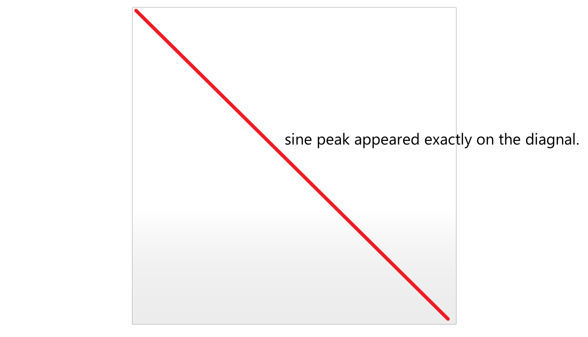
- One of the peaks of the "sine" / "cosine" wave should appear at the diagnal line of the topology (illustration below).
- Connect the modified points into curves.
- Loft the curves into a continuous surface.
Wave extremum location:

Part C: Soil Diagram with BAL (6pts)
You've learned how to use BeingAliveLanguage to draw soil diagrams. For this part of the assignment, you're asked to draw a soil diagram with multiple horizons with the provided soil data.
You need to submit a exported .pdf format drawing containing the following content:
- One soil profile diagram with multiple soil horizons
- For each horizon, label the corresponding soil type
- For each horizon, label the corresponding depth of each horizon inside the soil
Input File
The corresponding input files are provided on the MscLA server.
Assignment_03.zip
Submission
Name the submission file(s) with the following format:
LastName_FirstName_TimeForCompletion_AS03.xxx
Please submit the corresponding file(s) to the submission folder submissionAS03 on the server:
9_HS_24\02_MScLA-Semester-1\07_Digital-Design-Methods\Assignment\submissionAS03

